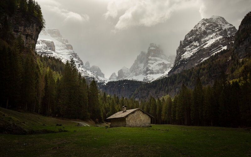
Malga Brenta Bassa | 1,250m (4,100 ft)
Location
S. Antonio Mavignola / Val Brenta
Description
A stunning natural amphitheater featuring large trees right in the heart of the Brenta valley and with a spectacular view of the central section of the Brenta Dolomites and the regal Crozzon di Brenta.
Access
TUR | QP 1,150m (3,775 ft) | QA 1,250m (4,100 ft)
From S. Antonio di Mavignola, take highway SS239 between Pinzolo and Madonna di Campiglio and follow the signs to Val Brenta. When you’ve passed the “Vivaio” and Agriturismo Pra della Casa and a few more curves along a dirt road, park in the area next to a gate preventing access to vehicles (the road you were just one continues to the right in the direction of Lake Valagola). Continue on foot along the same dirt road (trail no. 323), which rises slowly and constantly through a marvelous forest of larch and fir trees. After about 30 min., once you’ve past the view of a waterfall on your left and crossed a bridge over the waterway, you will get to the vast meadow of Malga Brenta Bassa, from where you can enjoy the spectacular view of the central section of the Brenta Dolomites. Itinerary suited to the whole family.
PHOTOGRAPHY INFO
Themes
Landscapes
An incomparable panorama throughout the drier months of the year, from just after the thaw in April to late October, when you can enjoy all the autumn hues of the forest.
Time
From at least mid-afternoon to sunset in order to have the sun to one side or at your back, when it will then shine on Crozzon and bathe the whole area in the warm colors of the sunset. In the morning, the sun will be directly in your face and make any type of shot difficult, but it’s still a good time for a bit of rest and relaxation or for a picnic in the shade of the trees while you wait for an afternoon of photography.
Legend
TUR = Touristic trail | ESC = Hiking trail | EE = Hiking trail for experts | T = time | QP = starting altitude | QA = arrival altitude

